波多馬克河
外觀
| 波多馬克河 Wappatomaka | |
|---|---|
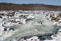
 冬季的波托馬克河大瀑布 | |
 波托馬克河流域圖 | |
| 國家 | |
| 州 | |
| 流域 | |
| 源頭 | Fairfax Stone |
| • 位置 | |
| • 座標 | 39°11′43″N 79°29′28″W / 39.19528°N 79.49111°W |
| • 海拔 | 3,060英尺(930公尺) |
| 河口 | 乞沙比克灣 |
| • 位置 | |
| • 座標 | 37°59′57″N 76°14′59″W / 37.99917°N 76.24972°W |
| • 海拔 | 0英尺(0公尺) |
| 城市 | 哈普斯渡口、坎伯蘭、華盛頓特區、阿靈頓、亞歷山德里亞 |
| 本貌 | |
| 長度 | 405 mi(652 km) |
| 流量 | |
| • 地點 | 巨岩點華盛頓特區附近的小瀑布 |
| • 最小流量 | 66 cu ft/s(1.9 m3/s) |
| • 最大流量 | 484,000 cu ft/s(13,700 m3/s) |
| 流量 | |
| • 地點 | 巨岩點 |
| • 平均流量 | 7,320 cu ft/s(207 m3/s) |
| 特徵 | |
| 左岸支流 | 莫諾卡西河、安那考斯迪亞河 |
| 右岸支流 | 雪蘭多亞河、奧科寬河 |
波多馬克河(英語:Potomac River)是美國東部的主要河流之一,為全美第21大河流。
波多馬克河有兩個源頭,北源發源於西維吉尼亞州普雷斯頓縣、格蘭特縣和塔克縣交界處,南源發源於維吉尼亞州高地縣,二者在漢普夏縣境內匯合後東流,後折向東南,成為馬里蘭州和西維吉尼亞州、維吉尼亞州和華盛頓哥倫比亞特區的邊界,最終注入乞沙比克灣。
波多馬克河全長約405英里(652公里)[1],流域面積14,700平方英里(38,000平方公里)[2],最大支流為南岸的謝南多亞河。
空難
[編輯]1982年1月13日,佛羅里達航空90號班機因為機翼結冰墜毀於波多馬克河,機上79人中,5人倖存。
參考
[編輯]- ^ U.S. Geological Survey. National Hydrography Dataset high-resolution flowline data. The National Map 網際網路檔案館的存檔,存檔日期March 29, 2012,.. Retrieved August 15, 2011
- ^ Facts & FAQs. Interstate Commission on the Potomac River Basin (ICPRB), Rockville, MD. September 16, 2009 [2010-02-05]. (原始內容存檔於January 15, 2010).
外部連結
[編輯]- Advanced Hydrologic Prediction Service (頁面存檔備份,存於網際網路檔案館) - Baltimore/Washington (Sterling, VA) - including Potomac River levels
- Potomac River level at Williamsport
- Potomac River level at Harpers Ferry
- Potomac River level at Point of Rocks
- Potomac River level at Little Falls
- Potomac River level at Wisconsin Avenue
- Interstate Commission on the Potomac River Basin (ICPRB) (頁面存檔備份,存於網際網路檔案館)
- Potomac Conservancy (頁面存檔備份,存於網際網路檔案館)
- Potomac Heritage National Scenic Trail (頁面存檔備份,存於網際網路檔案館)
- Potomac Riverkeeper (頁面存檔備份,存於網際網路檔案館)
- Potomac Watershed Partnership
- Potomac Watershed Roundtable (頁面存檔備份,存於網際網路檔案館)
- Prince William Conservation Alliance (頁面存檔備份,存於網際網路檔案館)
- Stewards of the Potomac Highlands
- West Virginia Division of Natural Resources
- West Virginia Rivers Coalition (頁面存檔備份,存於網際網路檔案館)
