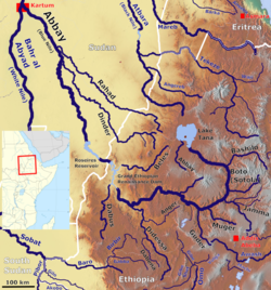
加瑪河
外觀
| 加瑪河 | |
|---|---|
 | |
| 流域 | |
| 河口 | 10°09′26″N 38°20′28″E / 10.1572°N 38.3412°E流入青尼羅河 |
| 流經國家 | 衣索比亞 |
加瑪河(Jamma River)是青尼羅河的右支流,流域包括阿姆哈拉州和奧羅米亞州,面積15,782平方公里.[1]。上加瑪河流經陡峭的峽谷、白堊紀時期形成的砂岩和頁岩。[2]
加瑪河在十四世紀被首次提及[3],傳教士佩德羅·波埃茲(Pedro Páez)是首個歐洲人到訪和描述青尼羅河的發源。
參考資料
[編輯]- ^ "Tana & Beles Integrated Water Resources Development: Project Appraisal Document (PAD), Vol.1" (頁面存檔備份,存於網際網路檔案館), World Bank, 2 May 2008 (accessed 5 May 2009)
- ^ "Local History in Ethiopia" (頁面存檔備份,存於網際網路檔案館) (pdf) The Nordic Africa Institute website (accessed 29 January 2008)
- ^ G.W.B. Huntingford, The historical geography of Ethiopia from the first century AD to 1704, (Oxford University Press: 1989), p. 69
外部連結
[編輯]- Ethiopia Disaster Prevention and Preparedness Agency: Administrative atlas: Oromiya region
- Ethiopia Disaster Prevention and Preparedness Agency: Flood Vulnerable Areas as of August 24, 2006
| 這是一篇與非洲相關的地理小作品。您可以透過編輯或修訂擴充其內容。 |
