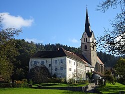
武泽尼察市镇
外观
| 武泽尼察市镇 Občina Vuzenica | |
|---|---|
| 市镇 | |
 教堂 | |
 在斯洛维尼亚的位置 | |
| 坐标:46°36′N 15°10′E / 46.600°N 15.167°E | |
| 国家 | |
| 行政中心 | 武泽尼察 |
| 政府 | |
| • 市长 | Franjo Golob |
| 面积 | |
| • 总计 | 50.1 平方公里(19.3 平方英里) |
| 人口(2020年)[1][2] | |
| • 总计 | 2,649人 |
| • 密度 | 52.9人/平方公里(137人/平方英里) |
| 时区 | CET(UTC+01) |
| • 夏时制 | CEST(UTC+02) |
武泽尼察市镇(斯洛维尼亚语:Občina Vuzenica),是斯洛维尼亚北部的一个市镇,行政中心为武泽尼察。位于德拉瓦河的右岸,向南延伸到波霍列山脉。该市镇在历史属于施蒂利亚公国的斯洛维尼亚部分,现在包括在科罗统计区[3]。
参考文献
[编辑]- ^ Razpotnik, Barica. On 1 January 2020, 2,095,861 residents of Slovenia lived in 5,978 settlements; 57 settlements were unpopulated (新闻稿). Ljubljana: Statistical Office of the Republic of Slovenia. 2020-06-08 [2021-01-08]. (原始内容存档于2022-04-20).
final data (XLS attachment)
- ^ Prebivalci po spolu, občine in naselja, Slovenija, 1. januar 2020 [Population by sex, municipalities and resorts, Slovenia, 1 January 2020]. Statistical Office of the Republic of Slovenia (XLS) (Ljubljana). 2020-06-08 [2021-01-08]. (原始内容存档于2020-06-08) (斯洛文尼亚语).
(note: for Vuzenica, the municipality is at code 141, followed immediately by its settlements at codes 141001–141105)
- ^ Vuzenica municipal site. [2021-12-17]. (原始内容存档于2017-01-11).
外部链接
[编辑]- 官方网站
 (斯洛文尼亚文)
 - Municipality of Vuzenica on Geopedia (页面存档备份,存于互联网档案馆)

