格兰德美尔州立公园
外观
| 格兰德美尔州立公园 | |
|---|---|
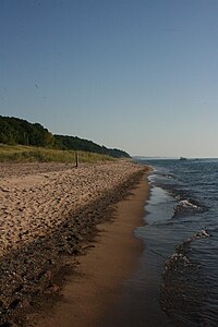
 格兰德美尔州立公园的一个沙滩 | |
| 位置 | 林肯镇区 贝林县 |
| 最近城镇 | 史蒂芬斯维尔县 |
| 坐标 | 42°00′30″N 86°32′20″W / 42.00833°N 86.53889°WGrand Mere State Park. Geographic Names Information System. United States Geological Survey. |
| 面积 | 985英亩(399公顷) |
| 海拔 | 587英尺(179米) [2] |
| 指定 | 密歇根州立公园 |
| 建立 | 1973[3] |
| 管理者 | 密歇根州自然资源部 |
| 网站 | Grand Mere State Park |
| 评定时间 | 1968 |
格兰德美尔州立公园 (Grand Mere State Park)是一个位于美国密歇根州史蒂芬斯维尔县的自然保护及公众娱乐区。州立公园位于94号州际公路旁,公园西边的沙丘保护著密歇根湖,令公园具有许多州内其他地方尚未发现的自然景观[4]。1968年被美国政府指定为美国国家自然地标[5]。
地理
[编辑]格兰德美尔州立公园占地985-英亩(3.99-平方千米),大部份占地被林植覆盖。原本园内有五个由冰河时期冰层溶化后而成的内陆湖[6],现时因自然流失,只剩三个[7] 。公园的沙丘更创造了一个相对凉爽的环境,令在密歇根州南部不常见的植物得以生存,当中有些植物被归类为“稀有”或“濒危”[6]。
活动及设施
[编辑]格兰德美尔州立公园提供游泳、登山、野餐、船舶下水装置及越野滑雪设施[4]。公园两英里外有一个沙滩,徒步走过沙丘便可到达。园内更有多个供登山及越野滑雪用的小径,但大部份均无人保养或驻守[6],小径禁止踏单车。小径地质由散沙至压土不等。园内有多座山,包括一个曾开放给越野车的大沙丘。但现时沙丘已有栏杆阻隔,大型四轮车已被禁止入内。
参考来源
[编辑]- ^ Grand Mere State Park. Protected Planet. IUCN. [March 27, 2020]. (原始内容存档于2018-02-19).
- ^ Grand Mere State Park. Geographic Names Information System. United States Geological Survey.
- ^ 3.0 3.1 When were Michigan state parks and recreation areas established? (PDF). Michigan Department of Natural Resources. [March 27, 2020]. (原始内容存档 (PDF)于2019-04-19).
- ^ 4.0 4.1 4.2 Grand Mere State Park. Michigan Department of Natural Resources. [February 18, 2018]. (原始内容存档于2019-11-03).
- ^ 5.0 5.1 Grand Mere Lakes. National Natural Landmarks. National Park Service. [February 18, 2018]. (原始内容存档于2019-07-13).
- ^ 6.0 6.1 6.2 6.3 DuFresne, Jim (2005). The Complete Guide to Michigan Sand Dunes, pp. 30-32. The University of Michigan Press.047203118X
- ^ 7.0 7.1 Grand Mere. Natural Areas. Michigan Department of Natural Resources. [March 27, 2020]. (原始内容存档于2020-07-20).
外部链接
[编辑]- 格兰德美尔州立公园网页 (页面存档备份,存于互联网档案馆)
- 格兰德美尔州立公园地图 (页面存档备份,存于互联网档案馆)

