卢阿莫图
外观
8°36′34″S 179°05′57″E / 8.6095°S 179.0991°E

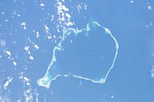
卢阿莫图(英語:Luamotu Isle)是一個位於吐瓦魯首都富納富提的一座珊瑚礁島嶼。該島嶼的海岸线正在被侵蚀。該珊瑚礁形成於全新世中期。[1]
参考文献
[编辑]- ^ The SAGE Handbook of Environmental Change - 第 1 卷 - 第 291 页. 在书中找到匹配结果 – 第 291 页 Figure 37.5 Eroding shoreline of Luamotu Island, Funafuti Atoll, Tuvalu. Like most atoll islands in this region, Luamotu has a foundation of resistant fossil reef (produced during the mid-Holocene sea-level maximum), shown here rising ... [2022-01-27]. (原始内容存档于2022-01-27).
| 这是一篇图瓦卢地理小作品。您可以通过编辑或修订扩充其内容。 |
