File:Thornapple TIGER Irving dam area map3c.PNG
页面内容不支持其他语言。
外观
Thornapple_TIGER_Irving_dam_area_map3c.PNG (422 × 359像素,文件大小:7 KB,MIME类型:image/png)
摘要

|
File:Thornapple TIGER Irving dam area map3c.svg是此文件的矢量版本。 应当将此点阵图片替换为该文件。
File:Thornapple TIGER Irving dam area map3c.PNG → File:Thornapple TIGER Irving dam area map3c.svg
更多信息请参阅Help:SVG/zh。
|
| 相机位置 | 42° 41′ 28.21″ 北, 85° 24′ 57.1″ 西 | 在以下服务上查看本图像和附近其他图像: OpenStreetMap |
|---|
| 描述Thornapple TIGER Irving dam area map3c.PNG |
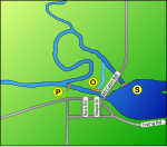
A map of the area of the Irving Dam in Irving, Michigan on the Thornapple River. The Irving dam is actually three different structures, which are labeled on the map as follows:
This map is modified from a USGS/USCB TIGER generated map - link to original map This TerraServer-USA topographical map shows the area clearly as well. Google maps are lacking in detail in this area. |
| 日期 | Generated on January 13, 2007 |
| 来源 | US gov |
| 作者 | Generated by User:Lar (w:en:User:Lar) using US Government provided TIGER tool |
| 授权 (二次使用本文件) |
PD US Government - TIGER is a service of the United States Census Bureau, and therefore the base image, like all TIGER images, is in the public domain. This derived image is Dual licensed under GFDL and Creative Commons Attribution 2.5 (CC-BY 2.5) |
| 其他版本 |
pictures of the dams are available for review at this Maj.com gallery. contact uploader who will happily upload additional ones. Note: Other versions of this drawing are available on request. (for example, without the letters) At this time, no SVG version is available (see below, one has been requested by inclusion of the {{Convert to SVG}}) template). In the event one is created, a crosslink will be added if notified. If you are interested in creating an SVG, contact the uploader, who may be able to suggest additional resources to improve the image from what is shown here. |
许可协议
我,本作品著作权人,特此采用以下许可协议发表本作品:

|
已授权您依据自由软件基金会发行的无固定段落及封面封底文字(Invariant Sections, Front-Cover Texts, and Back-Cover Texts)的GNU自由文件许可协议1.2版或任意后续版本的条款,复制、传播和/或修改本文件。该协议的副本请见“GNU Free Documentation License”。http://www.gnu.org/copyleft/fdl.htmlGFDLGNU Free Documentation Licensetruetrue |
| 本文件采用知识共享署名-相同方式共享 3.0 未本地化版本许可协议授权。 | ||
| ||
| 本许可协议标签作为GFDL许可协议更新的组成部分被添加至本文件。http://creativecommons.org/licenses/by-sa/3.0/CC BY-SA 3.0Creative Commons Attribution-Share Alike 3.0truetrue |
您可以选择您需要的许可协议。
说明
添加一行文字以描述该文件所表现的内容
此文件中描述的项目
描繪內容
42°41'28.21"N, 85°24'57.10"W
文件历史
点击某个日期/时间查看对应时刻的文件。
| 日期/时间 | 缩略图 | 大小 | 用户 | 备注 | |
|---|---|---|---|---|---|
| 当前 | 2007年1月14日 (日) 01:10 |  | 422 × 359(7 KB) | Lar | {{Location dec US|.90835|-85.49891}} {{Information |Description=A map of the area of the Irving Dam in Irving, Michigan on the Thornapple River. The Irving dam is actually three different stru |
文件用途
没有页面链接到本图像。
隐藏分类:


