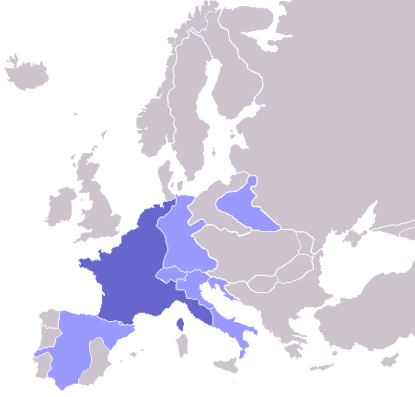
File:Europe map Napoleon 1811.png
外观
Europe_map_Napoleon_1811.png (415 × 397像素,文件大小:62 KB,MIME类型:image/png)
文件历史
点击某个日期/时间查看对应时刻的文件。
| 日期/时间 | 缩略图 | 大小 | 用户 | 备注 | |
|---|---|---|---|---|---|
| 当前 | 2022年10月11日 (二) 08:06 |  | 415 × 397(62 KB) | Рагин1987 | Extended map |
| 2020年7月23日 (四) 13:01 |  | 415 × 422(13 KB) | Leonel Sohns | Reverted to version as of 00:53, 16 October 2006 (UTC) | |
| 2020年7月23日 (四) 13:01 |  | 415 × 422(11 KB) | Leonel Sohns | Recovered old version from archive.org | |
| 2006年10月16日 (一) 00:53 |  | 415 × 422(13 KB) | Deltabeignet | Corrected status of Illyrian provinces. | |
| 2005年8月21日 (日) 00:51 |  | 415 × 422(11 KB) | OwenBlacker | Map of the w:First French Empire and satellite states, with w:1811 borders. Created by User:OwenBlacker from Image:Europe blank map.png {{GFDL}} {{cc-by-sa-2.0-uk}} |
文件用途
全域文件用途
以下其他wiki使用此文件:
- arz.wikipedia.org上的用途
- ast.wikipedia.org上的用途
- ba.wikipedia.org上的用途
- be.wikipedia.org上的用途
- bg.wikipedia.org上的用途
- bn.wikibooks.org上的用途
- bs.wikipedia.org上的用途
- ca.wikipedia.org上的用途
- cs.wikipedia.org上的用途
- cv.wikipedia.org上的用途
- de.wikibooks.org上的用途
- en.wikipedia.org上的用途
- en.wikibooks.org上的用途
- eo.wikipedia.org上的用途
- fi.wikipedia.org上的用途
- Cisalppinen tasavalta
- Batavian tasavalta
- Hollannin kuningaskunta
- Napolin kuningaskunta
- Helvetian tasavalta
- Ligurian tasavalta
- Varsovan herttuakunta
- Malline:Napoleonin vasallit
- Etrurian kuningaskunta
- Alban tasavalta
- Reinin liitto (1806)
- Italian tasavalta (vasalli)
- Mainzin tasavalta
- Italian kuningaskunta (Napoleon)
- Cispadaaninen tasavalta
- Westfalenin kuningaskunta
- Illyrian provinssit
- Transpadaaninen tasavalta
- fr.wikipedia.org上的用途
- fy.wikipedia.org上的用途
- gl.wikipedia.org上的用途
- he.wikipedia.org上的用途
- hr.wikipedia.org上的用途
- hu.wikipedia.org上的用途
查看此文件的更多全域用途。


