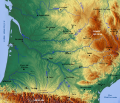
File:Topographic map of South-West France with main rivers and cities.svg
外觀

此 SVG 檔案的 PNG 預覽的大小:696 × 599 像素。 其他解析度:279 × 240 像素 | 558 × 480 像素 | 892 × 768 像素 | 1,190 × 1,024 像素 | 2,379 × 2,048 像素 | 1,028 × 885 像素。
原始檔案 (SVG 檔案,表面大小:1,028 × 885 像素,檔案大小:2.9 MB)
檔案歷史
點選日期/時間以檢視該時間的檔案版本。
| 日期/時間 | 縮圖 | 尺寸 | 使用者 | 備註 | |
|---|---|---|---|---|---|
| 目前 | 2010年3月13日 (六) 12:26 |  | 1,028 × 885(2.9 MB) | Pethrus | Mediawiki bug with "text along path" fix, slightly bigger fonts |
| 2010年3月11日 (四) 19:47 |  | 1,028 × 885(2.9 MB) | Pethrus | {{Information |Description={{en|Topographic map of the South-West of France with main rivers and cities}}{{fr|Carte topographique du Sud-Ouest de la France avec rivières et villes principales}} |Source={{own}} based on a [http://www.maps-for-free.com www |
檔案用途
下列頁面有用到此檔案:
全域檔案使用狀況
以下其他 wiki 使用了這個檔案:
- en.wikipedia.org 的使用狀況
- fr.wikipedia.org 的使用狀況
- sl.wikipedia.org 的使用狀況


