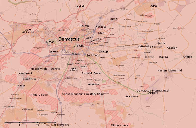
File:Rif Damashq.svg
外觀

此 SVG 檔案的 PNG 預覽的大小:800 × 523 像素。 其他解析度:320 × 209 像素 | 640 × 418 像素 | 1,024 × 670 像素 | 1,280 × 837 像素 | 2,560 × 1,674 像素 | 1,485 × 971 像素。
原始檔案 (SVG 檔案,表面大小:1,485 × 971 像素,檔案大小:7.38 MB)
檔案歷史
點選日期/時間以檢視該時間的檔案版本。
| 日期/時間 | 縮圖 | 尺寸 | 使用者 | 備註 | |
|---|---|---|---|---|---|
| 目前 | 2018年5月22日 (二) 02:15 |  | 1,485 × 971(7.38 MB) | Kami888 | damascus cleared |
| 2018年5月8日 (二) 05:56 |  | 1,485 × 971(7.38 MB) | Kami888 | updates | |
| 2018年5月4日 (五) 18:00 |  | 1,485 × 971(7.38 MB) | Kami888 | Evacuation of HTS and other non-ISIS rebels, ISIS pocket reported to be split in two. | |
| 2018年4月29日 (日) 18:41 |  | 1,485 × 971(7.39 MB) | Kami888 | ISIS withdrew from Qadam http://www.syriahr.com/en/?p=90681 | |
| 2018年4月26日 (四) 13:34 |  | 1,485 × 971(7.39 MB) | Kami888 | Taking update from https://pbs.twimg.com/media/Dbp4AVbX0AAxqSe.jpg:large as the only source that I know of that reports on situation in south damascus | |
| 2018年4月14日 (六) 02:42 |  | 1,485 × 971(7.39 MB) | Kami888 | Army of Islam evacuated from Douma | |
| 2018年4月1日 (日) 23:19 |  | 1,485 × 971(7.45 MB) | Kami888 | FAR and HTS evacuated to Idlib http://www.syriahr.com/2018/03/31/%d8%a8%d8%a7%d8%b3%d8%aa%d8%ab%d9%86%d8%a7%d8%a1-%d8%af%d9%88%d9%85%d8%a7-%d9%82%d9%88%d8%a7%d8%aa-%d8%a7%d9%84%d9%86%d8%b8%d8%a7%d9%85-%d8%aa%d9%81%d8%b1%d8%b6-%d8%b3%d9%8a%d8%b7%d8%b1%d8%aa/ | |
| 2018年3月27日 (二) 03:16 |  | 1,485 × 971(7.71 MB) | Kami888 | Changed Harasta to red per suggestion on talk page. Other towns still evacuating. | |
| 2018年3月25日 (日) 10:43 |  | 1,485 × 971(7.76 MB) | Kami888 | Changed Ein Terma/Hazeh. Evacuation from the other towns still appears to be ongoing. | |
| 2018年3月20日 (二) 12:00 |  | 1,485 × 971(7.77 MB) | Kami888 | south Qadam to contested |
檔案用途
全域檔案使用狀況
以下其他 wiki 使用了這個檔案:
- ar.wikipedia.org 的使用狀況
- be.wikipedia.org 的使用狀況
- ckb.wikipedia.org 的使用狀況
- en.wikipedia.org 的使用狀況
- es.wikipedia.org 的使用狀況
- fa.wikipedia.org 的使用狀況
- fo.wikipedia.org 的使用狀況
- hu.wikipedia.org 的使用狀況
- hy.wikipedia.org 的使用狀況
- id.wikipedia.org 的使用狀況
- ko.wikipedia.org 的使用狀況
- ku.wikipedia.org 的使用狀況
- pa.wikipedia.org 的使用狀況
- pl.wikipedia.org 的使用狀況
- pt.wikipedia.org 的使用狀況
- ru.wikipedia.org 的使用狀況
- tr.wikipedia.org 的使用狀況
- www.wikidata.org 的使用狀況


