
File:Europa 1815.svg

此 SVG 檔案的 PNG 預覽的大小:589 × 599 像素。 其他解析度:236 × 240 像素 | 472 × 480 像素 | 755 × 768 像素 | 1,007 × 1,024 像素 | 2,013 × 2,048 像素 | 1,340 × 1,363 像素。
原始檔案 (SVG 檔案,表面大小:1,340 × 1,363 像素,檔案大小:554 KB)
摘要
| 描述 |
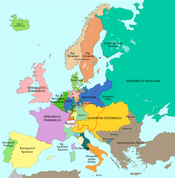
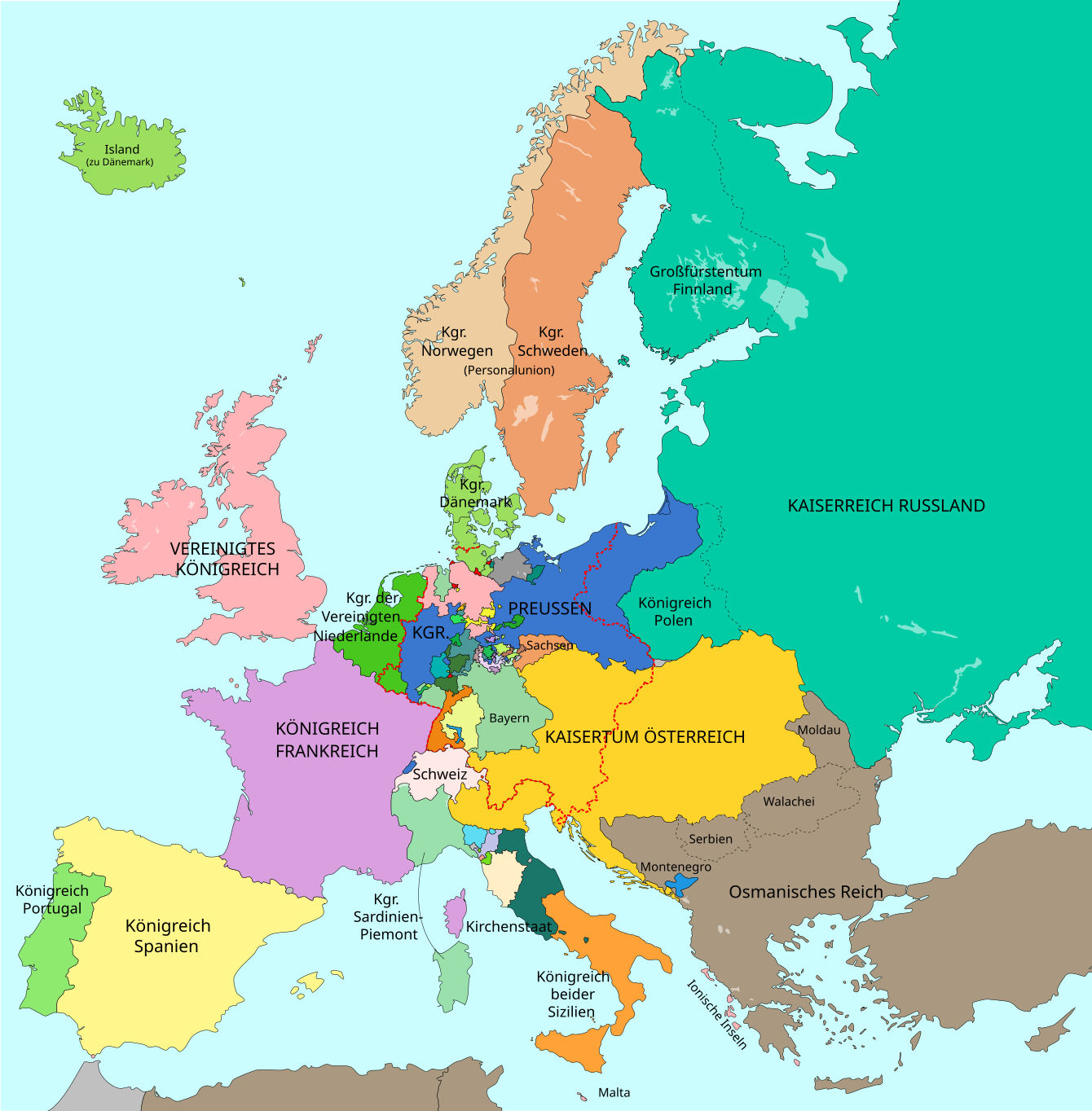
Deutsch: Europa im Jahr 1815 nach dem Wiener Kongress. Großmächte in GROSSBUCHSTABEN.
Russland
Frankreich
Vereinigtes Königreich
Preußen
Österreich und habsburgischer Besitz
Grenze des Deutschen Bundes (1815) English: Map of Europe 1815 after the Congress of Vienna. Great Powers in CAPITAL LETTERS.
Russia
France
United Kingdom
Prussia
Austria and Habsburg possessions
Border of the German Confederation (1815) Català: Mapa d'Europa 1815 després del Congrés de Viena. Grans potències en lletra majúscula.
Rússia
França
Regne Unit
Prússia
Àustria i possessions dels Habsburg
Frontera de la Confederació Alemanya (1815) |
| 日期 | (UTC), largely revised version: 2016-10-06 |
| 來源 |
本檔案衍生自: A blank map of Europe ca. 1815.svg: File:A blank map of Europe ca. 1815.svg |
| 作者 |
|
| 其他版本 |
|
| SVG開發 |


|
This SVG file contains embedded text that can be translated into your language, using any capable SVG editor, text editor or the SVG Translate tool. For more information see: About translating SVG files. |
_en.png)
.png)
.jpg)
授權條款

|
已授權您依據自由軟體基金會發行的無固定段落、封面文字和封底文字GNU自由文件授權條款1.2版或任意後續版本,對本檔進行複製、傳播和/或修改。該協議的副本列在GNU自由文件授權條款中。 |
| 此檔案採用共享創意 姓名標示-相同方式分享 3.0 未在地化版本授權條款。 | ||
| ||
| 已新增授權條款標題至此檔案,作為GFDL授權更新的一部份。 |
此檔案採用創用CC 姓名標示-相同方式分享 2.5 通用版授權條款。
- 您可以自由:
- 分享 – 複製、發佈和傳播本作品
- 重新修改 – 創作演繹作品
- 惟需遵照下列條件:
- 姓名標示 – 您必須指名出正確的製作者,和提供授權條款的連結,以及表示是否有對內容上做出變更。您可以用任何合理的方式來行動,但不得以任何方式表明授權條款是對您許可或是由您所使用。
- 相同方式分享 – 如果您利用本素材進行再混合、轉換或創作,您必須基於如同原先的相同或兼容的條款,來分布您的貢獻成品。
原始上傳日誌
This image is a derivative work of the following images:
- File:Map-GermanConfederation.svg licensed with Cc-by-sa-2.5, Cc-by-sa-3.0-migrated, GFDL, GFDL-user-en-note
- 2011-01-18T15:49:48Z Beao 9031x7615 (1364487 Bytes) Removed border
- 2007-04-13T19:20:08Z 52 Pickup 9086x7672 (1815864 Bytes) {{Information| |Description= The [[:en:German Confederation|German Confederation]] ([[:de:Deutscher Bund|Deutscher Bund]]) - map from 1820 |Source= Based on map data of the IEG-Maps project (Andreas Kunz, B. Johnen and Joachi
Uploaded with derivativeFX
檔案歷史
點選日期/時間以檢視該時間的檔案版本。
| 日期/時間 | 縮圖 | 尺寸 | 用戶 | 備註 | |
|---|---|---|---|---|---|
| 目前 | 2023年9月15日 (五) 12:46 | | 1,340 × 1,363(554 KB) | Lalpino | File uploaded using svgtranslate tool (https://svgtranslate.toolforge.org/). Added translation for ca. |
| 2016年10月30日 (日) 17:30 |  | 1,340 × 1,363(549 KB) | Furfur | kleine Korrekturen (Fürstentum Birkenfeld, Wetzlar, Freie Stadt Frankfurt, Hessen-Homburg) | |
| 2016年10月22日 (六) 10:19 |  | 1,340 × 1,363(548 KB) | Furfur | Schweden und Norwegen doch verschieden eingefärbt – trotz Personalunion zwei verschiedene Staaten; Algerien und Tunesien in der Farbe des Osmanischen Reichs | |
| 2016年10月20日 (四) 11:07 |  | 1,340 × 1,363(547 KB) | Furfur | Details (u. a. Bild vergrößert, Meeresdarbe heller) | |
| 2016年10月6日 (四) 19:33 |  | 893 × 907(521 KB) | Furfur | Detailkorrektur | |
| 2016年10月6日 (四) 19:26 |  | 893 × 907(521 KB) | Furfur | Details | |
| 2016年10月6日 (四) 19:07 |  | 893 × 907(520 KB) | Furfur | Korrekturen | |
| 2016年10月6日 (四) 18:59 |  | 893 × 907(518 KB) | Furfur | bessere Karte | |
| 2016年9月29日 (四) 16:54 |  | 905 × 762(2.16 MB) | Furfur | Detail (Meer etwas heller) | |
| 2014年12月9日 (二) 16:59 |  | 905 × 762(2.16 MB) | Furfur | + blue coast line |
檔案用途
下列頁面有用到此檔案:
全域檔案使用狀況
以下其他 wiki 使用了這個檔案:
- af.wikipedia.org 的使用狀況
- azb.wikipedia.org 的使用狀況
- ca.wikipedia.org 的使用狀況
- de.wikipedia.org 的使用狀況
- en.wikipedia.org 的使用狀況
- eo.wikipedia.org 的使用狀況
- et.wikipedia.org 的使用狀況
- it.wikipedia.org 的使用狀況
- rm.wikipedia.org 的使用狀況
- stq.wikipedia.org 的使用狀況