跳至內容

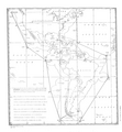
File:Declaration of Panama map.png

頁面內容不支援其他語言。
這個檔案來自維基共享資源
維基百科,自由的百科全書

原始檔案 (1,674 × 1,806 像素,檔案大小:835 KB,MIME 類型:image/png


摘要

描述
English: A draft map used as the basis of the Declaration of Panama, 1939. The hand drawn straight lines between the marks "x" labelled "A" to "L" (missing "D") were personally drawn by President Roosevelt. The points are on arcs prepared by a draftsman 300 nautical miles from the coast, so the area defined mostly exceeds 300 nautical miles offshore. These points were used as the basis of the textual description defining the area in the Declaration of Panama.[1]
Deutsch: Entwurfsskizze der panamerikanischen Sicherheitszone (Panamaerklärung 1939)
日期
來源 http://images.library.wisc.edu/FRUS/EFacs/1939v05/reference/frus.frus1939v05.i0004.pdf#page=21
作者 U.S. Department of State

授權條款

Public domain
此作品在美國屬於公有領域,因為其是由美國政府的官員或僱員,基於其個人公務目的製作的作品,參考美國法典第17篇第1章第105條
注意︰本模板僅適用於美國聯邦政府的原創作品,不適用於任何美國州屬地、聯邦個體、縣、市或任何次級政府的作品。本模板也不適用於1978年以後美國郵政署出版的郵票圖案(參看美國版權局實踐綱領第313.6(C)(1)條)。也不適用於部分美國硬幣;參看美國鑄幣局使用條款
此作品無已知的著作權限制,亦不受所有相關和鄰接的權利限制。

說明

添加單行說明來描述出檔案所代表的內容

在此檔案描寫的項目

描繪內容

著作權狀態 繁體中文 (已轉換拼寫)

斷定方法:​美國聯邦政府的作品 繁體中文 (已轉換拼寫)

檔案歷史

點選日期/時間以檢視該時間的檔案版本。

日期/時間縮⁠圖尺寸用戶備⁠註
目前2018年11月20日 (二) 12:20於 2018年11月20日 (二) 12:20 版本的縮圖1,674 × 1,806(835 KB)RwendlandUser created page with UploadWizard

下列頁面有用到此檔案:

全域檔案使用狀況

以下其他 wiki 使用了這個檔案:

詮釋資料