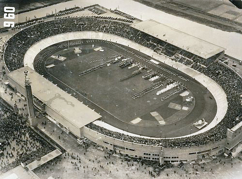
File:Olympic Stadium Amsterdam 1928.jpg
外觀
Olympic_Stadium_Amsterdam_1928.jpg (500 × 369 像素,檔案大小:205 KB,MIME 類型:image/jpeg)
檔案歷史
點選日期/時間以檢視該時間的檔案版本。
| 日期/時間 | 縮圖 | 尺寸 | 用戶 | 備註 | |
|---|---|---|---|---|---|
| 目前 | 2012年8月12日 (日) 12:19 |  | 500 × 369(205 KB) | Soerfm | Color |
| 2005年12月17日 (六) 15:26 |  | 500 × 369(57 KB) | Chigliak | taken from Dutch wikipedia nl:Afbeelding:Olym_stadion.jpg Description there: Luchtfoto van het Olympisch Stadion tijdens de openingsceremonie van de Olympische Spelen. Nederland - Uruguay (0-2), gespeeld op 30 mei 1928 in het Olympisch Stadion te Am |
檔案用途
下列3個頁面有用到此檔案:
全域檔案使用狀況
以下其他 wiki 使用了這個檔案:
- af.wikipedia.org 的使用狀況
- an.wikipedia.org 的使用狀況
- ar.wikipedia.org 的使用狀況
- ast.wikipedia.org 的使用狀況
- bn.wikipedia.org 的使用狀況
- bs.wikipedia.org 的使用狀況
- ca.wikipedia.org 的使用狀況
- da.wikipedia.org 的使用狀況
- de.wikipedia.org 的使用狀況
- en.wikipedia.org 的使用狀況
- es.wikipedia.org 的使用狀況
- eu.wikipedia.org 的使用狀況
- fa.wikipedia.org 的使用狀況
- fi.wikipedia.org 的使用狀況
- fr.wikipedia.org 的使用狀況
- fy.wikipedia.org 的使用狀況
檢視此檔案的更多全域使用狀況。


