
File:Manantali dam.jpg
此為最大尺寸。
Manantali_dam.jpg (800 × 158 像素,檔案大小:28 KB,MIME 類型:image/jpeg)
摘要
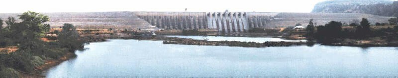
| 描述 | Mali's second multi-purpose dam, Manantali Dam, is located approximately 1200 km. upstream, and was built by the OMVS on the Bafig tributary of the Senegal River in Mali. |
| 日期 | |
| 來源 |
http://www.fas.usda.gov/pecad2/highlights/2001/10/senegal/pictures/Manantali_dam.jpg "Rice Production in Senegal Sustained", United States Department of Agriculture Foreign Agricultural Service October 22, 2001 |
| 作者 | USDA, PECAD/FAS |
| 授權許可 (重用此檔案) |
PD |
授權條款
此作品在美國屬於公有領域,因為其是由美國政府的官員或僱員,基於其個人公務目的製作的作品,參考美國法典第17篇第1章第105條。
注意︰本模板僅適用於美國聯邦政府的原創作品,不適用於任何美國州、屬地、聯邦個體、縣、市或任何次級政府的作品。本模板也不適用於1978年以後由美國郵政署出版的郵票圖案(參看美國版權局實踐綱領第313.6(C)(1)條)。也不適用於部分美國硬幣;參看美國鑄幣局使用條款。 |
 | |
| 此作品無已知的著作權限制,亦不受所有相關和鄰接的權利限制。 | ||
檔案歷史
點選日期/時間以檢視該時間的檔案版本。
| 日期/時間 | 縮圖 | 尺寸 | 用戶 | 備註 | |
|---|---|---|---|---|---|
| 目前 | 2008年3月7日 (五) 00:19 | 800 × 158(28 KB) | T L Miles | {{Information |Description=Mali's second multi-purpose dam, Manantali Dam, is located approximately 1200 km. upstream, and was built by the OMVS on the Bafig tributary of the Senegal River in Mali. |Source=http://www.fas.usda.gov/pecad2/highlights/2001/10 |
檔案用途
全域檔案使用狀況
以下其他 wiki 使用了這個檔案:
- af.wikipedia.org 的使用狀況
- ar.wikipedia.org 的使用狀況
- arz.wikipedia.org 的使用狀況
- ast.wikipedia.org 的使用狀況
- bg.wikipedia.org 的使用狀況
- ca.wikipedia.org 的使用狀況
- ceb.wikipedia.org 的使用狀況
- cs.wikipedia.org 的使用狀況
- de.wikipedia.org 的使用狀況
- en.wikipedia.org 的使用狀況
- es.wikipedia.org 的使用狀況
- fa.wikipedia.org 的使用狀況
- fi.wikipedia.org 的使用狀況
- fr.wikipedia.org 的使用狀況
- gl.wikipedia.org 的使用狀況
- ja.wikipedia.org 的使用狀況
- lt.wikipedia.org 的使用狀況
- nl.wikipedia.org 的使用狀況
- no.wikipedia.org 的使用狀況
- pl.wikipedia.org 的使用狀況
- ru.wikipedia.org 的使用狀況
- uk.wikipedia.org 的使用狀況
- www.wikidata.org 的使用狀況