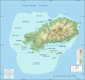
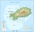
File:Rodrigues Island topographic map-fr.png
外觀

預覽大小:637 × 600 像素。 其他解析度:255 × 240 像素 | 510 × 480 像素 | 816 × 768 像素 | 1,088 × 1,024 像素 | 1,700 × 1,600 像素。
原始檔案 (1,700 × 1,600 像素,檔案大小:874 KB,MIME 類型:image/png)
檔案歷史
點選日期/時間以檢視該時間的檔案版本。
| 日期/時間 | 縮圖 | 尺寸 | 使用者 | 備註 | |
|---|---|---|---|---|---|
| 目前 | 2010年7月19日 (一) 13:41 |  | 1,700 × 1,600(874 KB) | Sting | Color profile |
| 2008年9月6日 (六) 02:43 |  | 1,700 × 1,600(814 KB) | Sting | Adding roads and other labels ; new standard colors | |
| 2008年5月14日 (三) 03:55 |  | 1,700 × 1,600(706 KB) | Sting | == Summary == {{Location|19|43|00|S|63|25|00|E|scale:200000}} <br/> {{Information |Description={{en|Topographic map in French of Rodrigues Island, Mauritius<br/>''Note :'' for translation purpose, use the [[:Ro |
檔案用途
下列頁面有用到此檔案:
全域檔案使用狀況
以下其他 wiki 使用了這個檔案:
- de.wikipedia.org 的使用狀況
- es.wikipedia.org 的使用狀況
- fr.wikipedia.org 的使用狀況
- mt.wikipedia.org 的使用狀況
- no.wikipedia.org 的使用狀況
- ro.wikipedia.org 的使用狀況
- sr.wikipedia.org 的使用狀況
- uk.wikipedia.org 的使用狀況


