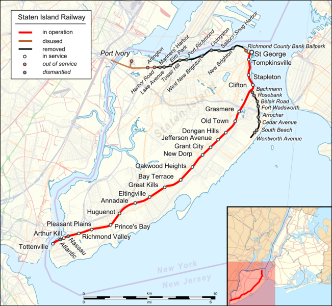
File:Map Staten Island Railway en.png
外觀

預覽大小:651 × 600 像素。 其他解析度:260 × 240 像素 | 521 × 480 像素 | 833 × 768 像素 | 1,111 × 1,024 像素 | 1,885 × 1,737 像素。
原始檔案 (1,885 × 1,737 像素,檔案大小:2.4 MB,MIME 類型:image/png)
檔案歷史
點選日期/時間以檢視該時間的檔案版本。
| 日期/時間 | 縮圖 | 尺寸 | 使用者 | 備註 | |
|---|---|---|---|---|---|
| 目前 | 2023年8月17日 (四) 19:22 |  | 1,885 × 1,737(2.4 MB) | DinoSoupCanada | Connected into NJ |
| 2018年4月29日 (日) 02:11 |  | 1,885 × 1,737(2.25 MB) | Pechristener | korr: Atlantic and Nassau stops were demolished | |
| 2018年4月29日 (日) 01:55 |  | 1,885 × 1,737(2.25 MB) | Pechristener | typos / Arthur Kill station | |
| 2016年11月22日 (二) 08:09 |  | 1,885 × 1,737(1.57 MB) | Kopiersperre | optipng | |
| 2016年11月22日 (二) 03:41 |  | 1,885 × 1,737(2.27 MB) | Pechristener | {{Map |Description={{en|1=Location map of {{w|Staten Island Railway}}. English Index}} |Source= * [http://www.openstreetmap.org/ Open Street Map] Data * {{f|USA_New_York_City_location_map.svg}} (for location map) |Author= * rendering with Maperitive,... |
檔案用途
下列頁面有用到此檔案:
全域檔案使用狀況
以下其他 wiki 使用了這個檔案:
- de.wikipedia.org 的使用狀況
- en.wikipedia.org 的使用狀況
- eo.wikipedia.org 的使用狀況
- ja.wikipedia.org 的使用狀況
- nl.wikipedia.org 的使用狀況
- uz.wikipedia.org 的使用狀況


