
File:Kerguelen-Plateau-Topography.jpg
無更高解析度可提供。
Kerguelen-Plateau-Topography.jpg (380 × 400 像素,檔案大小:37 KB,MIME 類型:image/jpeg)
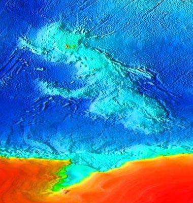
| 描述 | Topographical map of the submerged Kerguelen continent. | |||
| 日期 | (UTC) | |||
| 來源 | Source: [1]. Cropped from Image:Elevation.jpg. | |||
| 作者 | Wiz9999 | |||
| 授權許可 (重用此檔案) |
|
檔案歷史
點選日期/時間以檢視該時間的檔案版本。
| 日期/時間 | 縮圖 | 尺寸 | 使用者 | 備註 | |
|---|---|---|---|---|---|
| 目前 | 2007年5月10日 (四) 15:03 | | 380 × 400(37 KB) | Wiz9999 | |
| 2007年5月10日 (四) 14:45 |  | 4,320 × 2,160(1.86 MB) | Wiz9999 | {{Information |Description=Topographical map of the submerged Kerguelen continent. |Source=Source: [http://www.ngdc.noaa.gov/mgg/image/2minrelief.html]. Cropped from Image:Elevation.jpg. |Date=~~~~~ |Author=~~~ |Permission={{ |
檔案用途
全域檔案使用狀況
以下其他 wiki 使用了這個檔案:
- ar.wikipedia.org 的使用狀況
- az.wikipedia.org 的使用狀況
- be.wikipedia.org 的使用狀況
- bn.wikipedia.org 的使用狀況
- de.wikipedia.org 的使用狀況
- en.wikipedia.org 的使用狀況
- es.wikipedia.org 的使用狀況
- fr.wikipedia.org 的使用狀況
- Îles Kerguelen
- Discussion:Îles Kerguelen
- Plateau des Kerguelen
- Microcontinent
- Continent submergé
- Discussion:Îles Kerguelen/LSV 20623
- Wikipédia:Statistiques des anecdotes de la page d'accueil/Visibilité des anecdotes (2022)
- Wikipédia:Statistiques des anecdotes de la page d'accueil/Visibilité des anecdotes (2022)/2022 02
- Projet:Aide et accueil/Twitter/Tweets/archives/février 2022
- Wikipédia:Le saviez-vous ?/Archives/2022
- fy.wikipedia.org 的使用狀況
- he.wikipedia.org 的使用狀況
- hy.wikipedia.org 的使用狀況
- id.wikipedia.org 的使用狀況
- it.wikipedia.org 的使用狀況
- ja.wikipedia.org 的使用狀況
- ko.wikipedia.org 的使用狀況
- nl.wikipedia.org 的使用狀況
- pt.wikipedia.org 的使用狀況
- ru.wikipedia.org 的使用狀況
- simple.wikipedia.org 的使用狀況
- sv.wikipedia.org 的使用狀況
- ta.wikipedia.org 的使用狀況
- uk.wikipedia.org 的使用狀況
- ur.wikipedia.org 的使用狀況
- www.wikidata.org 的使用狀況
- zh-yue.wikipedia.org 的使用狀況