
File:DC Metro Map 2013.svg

此 SVG 檔案的 PNG 預覽的大小:566 × 599 像素。 其他解析度:227 × 240 像素 | 453 × 480 像素 | 726 × 768 像素 | 967 × 1,024 像素 | 1,935 × 2,048 像素 | 1,539 × 1,629 像素。
原始檔案 (SVG 檔案,表面大小:1,539 × 1,629 像素,檔案大小:4.48 MB)
摘要
| 描述 |
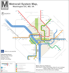
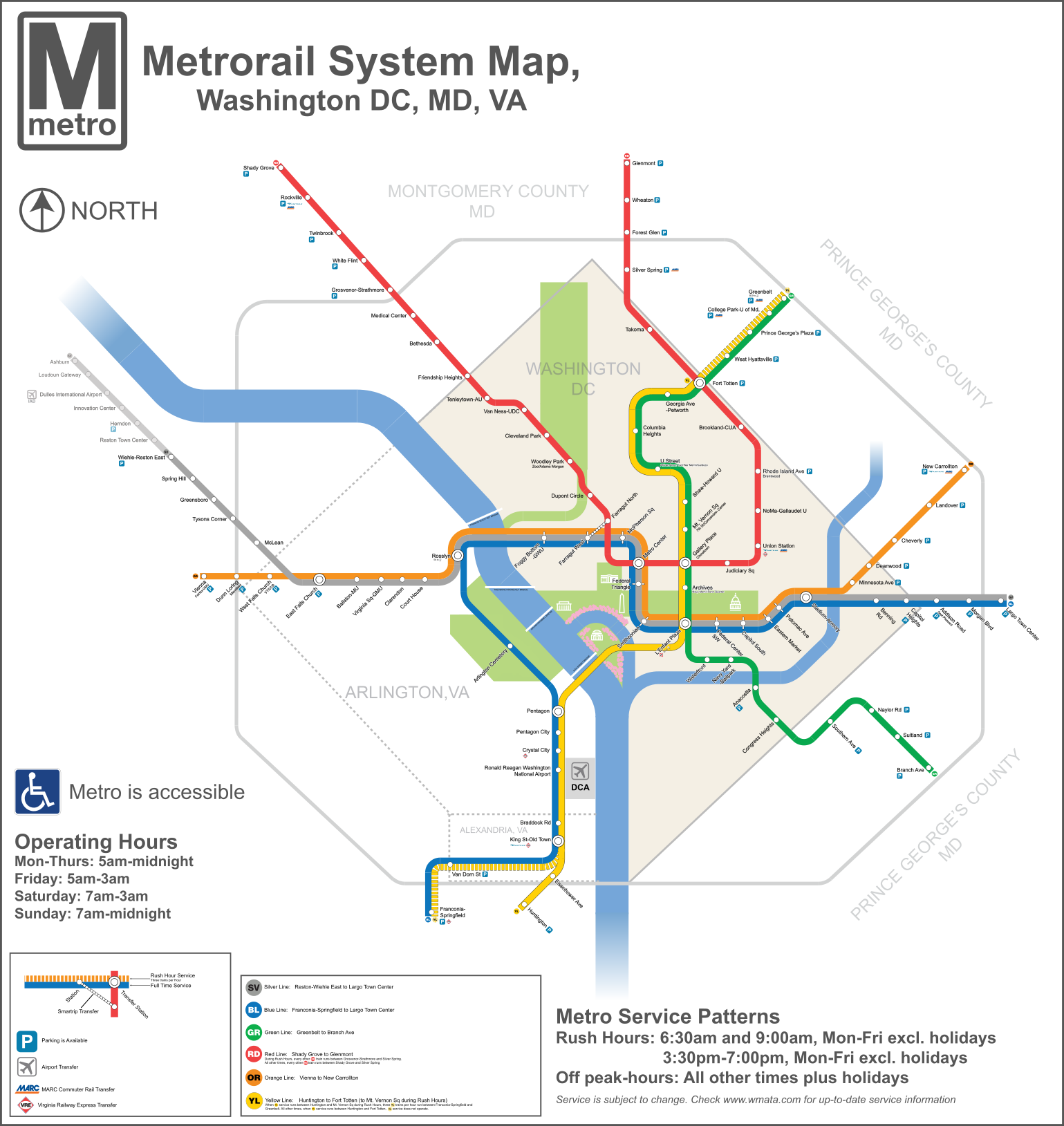
English: A redesigned map of the Washington Metro. Created using Adobe Illustrator. This map shows the Rush Plus service details and is designed to be more geographically matched than the current metro map. Two files from Commons were used in the creation of the Map. They are File:WMATA Metro Logo.svg, and File: Amtrak logo.svg |
| 日期 | |
| 來源 | 自己的作品 |
| 作者 | VeggieGarden |
本向量圖形使用Adobe Illustrator創作。

授權條款
我,本作品的著作權持有者,決定用以下授權條款發佈本作品:
| 此檔案在創用CC CC0 1.0 通用公有領域貢獻宣告之下分發。 | |
| 在此宣告之下分發本作品者,已依據各國著作權法,在全世界放棄其對本作品所擁有的著作權及所有相關相似的法律權利,從而將本作品貢獻至公有領域。您可以複製、修改、分發和演示該作品,用於任何商業用途,所有這些都不需要請求授權。
|
檔案歷史
點選日期/時間以檢視該時間的檔案版本。
| 日期/時間 | 縮圖 | 尺寸 | 使用者 | 備註 | |
|---|---|---|---|---|---|
| 目前 | 2015年12月3日 (四) 17:31 | | 1,539 × 1,629(4.48 MB) | Pi.1415926535 | Reduce height |
| 2015年12月3日 (四) 17:27 |  | 1,539 × 1,779(4.47 MB) | Pi.1415926535 | Fixed misaligned background | |
| 2015年12月2日 (三) 22:11 |  | 1,539 × 1,779(4.47 MB) | Pi.1415926535 | Update station names | |
| 2015年12月2日 (三) 21:24 |  | 1,539 × 1,779(4.48 MB) | Pi.1415926535 | Increase width for better visibility (no other changes) | |
| 2014年8月19日 (二) 09:23 |  | 512 × 592(4.09 MB) | Rcsprinter123 | Cemetery, Mongomery | |
| 2013年10月18日 (五) 02:06 |  | 512 × 592(3.98 MB) | VeggieGarden | Added parking at Wiehle-Reston East Station, fixed "accessible" spelling error | |
| 2013年10月16日 (三) 23:56 |  | 512 × 592(3.86 MB) | VeggieGarden | Fixed More Errors, made the map more readable | |
| 2013年10月16日 (三) 23:56 |  | 512 × 592(3.86 MB) | VeggieGarden | Fixed More Errors, made the map more readable | |
| 2013年10月16日 (三) 23:43 |  | 512 × 592(586 KB) | VeggieGarden | Fixed errors | |
| 2013年10月16日 (三) 23:35 |  | 512 × 592(284 KB) | VeggieGarden | Brand New design, more accurate, addition of Silver Line Phase 1. The map is also easier to understand. |
檔案用途
下列頁面有用到此檔案:
全域檔案使用狀況
以下其他 wiki 使用了這個檔案:
- en.wikipedia.org 的使用狀況
- pt.wikipedia.org 的使用狀況