
File:Antarctica (5), Adelaide Island, Webb Island.JPG
預覽大小:800 × 531 像素。 其他解析度:320 × 213 像素 | 640 × 425 像素 | 1,024 × 680 像素 | 1,280 × 850 像素 | 1,716 × 1,140 像素。
原始檔案 (1,716 × 1,140 像素,檔案大小:404 KB,MIME 類型:image/jpeg)
,_Adelaide_Island,_Webb_Island.JPG?uselang=zh-hant)
,_Adelaide_Island,_Webb_Island.JPG?uselang=zh-hant)
,_Adelaide_Island,_Webb_Island.JPG?action=history&uselang=zh-hant)
,_Adelaide_Island,_Webb_Island.JPG)
摘要
| 描述 |
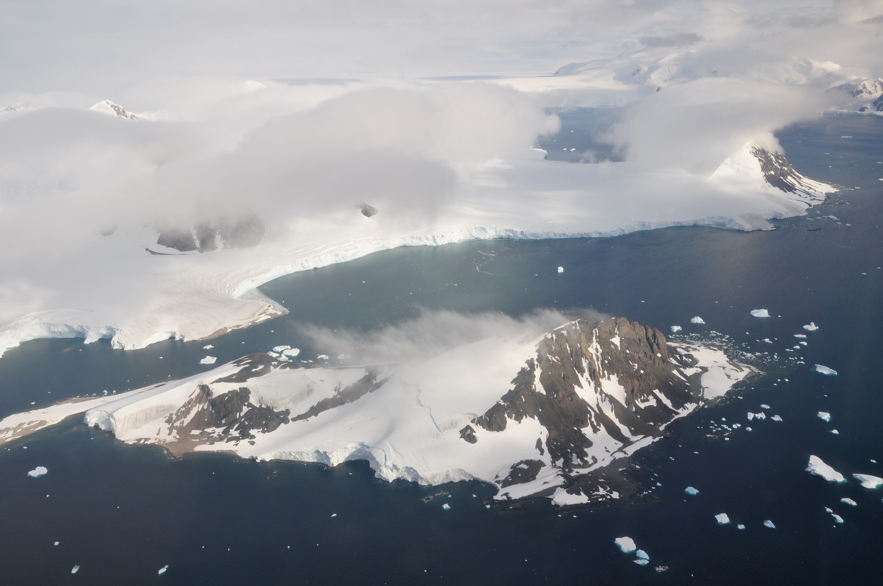
বাংলা: এই ছবিটি অ্যান্টার্কটিক উপদ্বীপের দক্ষিণ-পশ্চিম অঞ্চলের। এটি লুব্যফ সাগরখাঁড়ির উপর থেকে দ.-প. দিকে নেয়া একটি আন্তরীক্ষ দৃশ্য। ছবির পুরোভূমিতে ৩৯৮ মি শীর্ষ বিশিষ্ট ওয়েব দ্বীপ। এর পেছনে অ্যাডিলেড দ্বীপের পূর্ব উপকূলের রাইট উপদ্বীপের কিয়দাংশ। উপকূলের উঁচু ও খাড়া বরফ পাহাড়গুলো ৱোর্ম্যল্ড বরফ উপকূল থেকে এসেছে, যা রাইট উপদ্বীপের পূর্ব উপকূলের বেশীরভাগ আচ্ছাদন করে আছে। বামে মেঘে ঢাকা পর্বতগুলো হল স্টোকস শৃঙ্গ। ডানে মেঘে ঢাকা পর্বতটি রাইট উপদ্বীপের উ.-পূ. প্রান্তের দীর্ঘশ্বাস শৃঙ্গ; তার পেছনে পাথরবাড়ি উপসাগর। দীর্ঘশ্বাস শৃঙ্গের ডানের প্রণালীর নাম কোল প্রণালী (যা আসলে লুব্যফ সাগরখাঁড়ির অংশ)। ছবির উপরে ডানদিকের কোণায় স্তূপপর্বত বুভিয়ে শৃঙ্গ। মেঘের মাঝে একটি ছিদ্র দিয়ে পর্বতগুলোর পাদদেশে বিশৃঙ্খলা হিমবাহ সামান্য দেখা যায়। এটি অ্যাডিলেড দ্বীপের বৃহত্তম হিমবাহ এবং এতে অনেক গভীর ফাটল রয়েছে।
English: This picture is from the SW Antarctic Peninsula region. It's an aerial view from a position over Laubeuf Fjord, looking to the NW. In the foreground is Webb Island with its summit of 398 m. Behind it is a part of the Wright Peninsula on Adelaide Island's east coast. This coast's high ice cliffs are from the Wormald Ice Piedmont that covers most of the Wright Peninsula's east coast. The cloud-covered mountains on the left are the Stokes Peaks. The lone cloud-covered mountain at the right -at the NE extremity of the Wright Peninsula-is Sighing Peak; behind it is Stonehouse Bay. The maritime channel right of Sighing Peak is called Cole Channel (and is actually a part of Laubeuf Fjord). In the upper right hand corner of the picture is the Mount Bouvier Massif. At the foot of these mountains the Shambles Glacier can just be seen through a hole in the clouds. It is Adelaide Island's largest glacier and is heavily crevassed. |
| 日期 | |
| 來源 | 自己的作品 |
| 作者 | Vincent van Zeijst |
•
| 拍攝地點 | | 位於此地的本圖片與其他圖片: OpenStreetMap |
|---|
,_Adelaide_Island,_Webb_Island.JPG¶ms=-67.465978_N_-067.884522_E_globe:Earth_type:camera_heading:315.00&language=zh-hant)
授權條款
我,本作品的著作權持有者,決定用以下授權條款發佈本作品:
此檔案採用創用CC 姓名標示-相同方式分享 3.0 未在地化版本授權條款。
- 您可以自由:
- 分享 – 複製、發佈和傳播本作品
- 重新修改 – 創作演繹作品
- 惟需遵照下列條件:
- 姓名標示 – 您必須指名出正確的製作者,和提供授權條款的連結,以及表示是否有對內容上做出變更。您可以用任何合理的方式來行動,但不得以任何方式表明授權條款是對您許可或是由您所使用。
- 相同方式分享 – 如果您利用本素材進行再混合、轉換或創作,您必須基於如同原先的相同或兼容的條款,來分布您的貢獻成品。
檔案歷史
點選日期/時間以檢視該時間的檔案版本。
| 日期/時間 | 縮圖 | 尺寸 | 使用者 | 備註 | |
|---|---|---|---|---|---|
| 目前 | 2011年3月12日 (六) 13:01 | | 1,716 × 1,140(404 KB) | Loranchet | {{Information |Description ={{en|1=This picture is from the SW Antarctic Peninsula region. It's an aerial view from a position over Laubeuf Fjord, looking to the NW. In the foreground is Webb Island with its summit of 398 m. Behind it is a part |
檔案用途
全域檔案使用狀況
以下其他 wiki 使用了這個檔案:
- azb.wikipedia.org 的使用狀況
- bn.wikipedia.org 的使用狀況
- bn.wikibooks.org 的使用狀況
- de.wikipedia.org 的使用狀況
- en.wikipedia.org 的使用狀況
- it.wikivoyage.org 的使用狀況
- la.wikipedia.org 的使用狀況
- mk.wikipedia.org 的使用狀況
- ms.wikipedia.org 的使用狀況
- nn.wikipedia.org 的使用狀況
- no.wikipedia.org 的使用狀況
- sr.wikipedia.org 的使用狀況
- vi.wikipedia.org 的使用狀況
,_Adelaide_Island,_Webb_Island.JPG)