
File:1850 IC.jpg

原始檔案 (3,536 × 5,856 像素,檔案大小:2.99 MB,MIME 類型:image/jpeg)
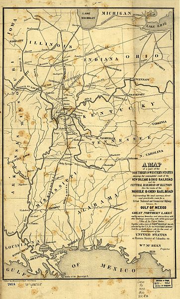
1850 map of the Illinois Central Railroad and New Orleans and Ohio Railroad (which became part of the IC) from [1]. Also shows the Mobile and Ohio Railroad, later part of the Gulf, Mobile and Ohio Railroad. Also shows the proposed "Western District of Columbia" where the two lines would meet, including Metropolis, Illinois and the never-built Capitol City, Kentucky.
|
本作品在其來源國以及其他著作權期限是作者逝世後70年或以下的國家與地區屬於公有領域。
| |
| 此作品無已知的著作權限制,亦不受所有相關和鄰接的權利限制。 | |
檔案歷史
點選日期/時間以檢視該時間的檔案版本。
| 日期/時間 | 縮圖 | 尺寸 | 使用者 | 備註 | |
|---|---|---|---|---|---|
| 目前 | 2005年8月26日 (五) 12:13 | | 3,536 × 5,856(2.99 MB) | SPUI~commonswiki | {{PD}} 1850 map of the Illinois Central Railroad and New Orleans and Ohio Railroad (which became part of the IC) from [http://memory.loc.gov/cgi-bin/query/r?ammem/gmd:@field(NUMBER+@band(g4041p+rr004740))]. Also shows the Mobile and Ohio Railroad, later p |
檔案用途
下列頁面有用到此檔案:
全域檔案使用狀況
以下其他 wiki 使用了這個檔案:
- de.wikipedia.org 的使用狀況
- en.wikipedia.org 的使用狀況
- eo.wikipedia.org 的使用狀況
- ja.wikipedia.org 的使用狀況