跳转到内容

File:Tropical Cyclone Hubert 2006.jpg

页面内容不支持其他语言。
这个文件来自维基共享资源
维基百科,自由的百科全书

原始文件 (5,600 × 5,600像素,文件大小:3.6 MB,MIME类型:image/jpeg


摘要

描述

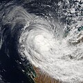
Tropical Cyclone Hubert formed off the northwestern coast of Australia on April 5, 2006. Cyclones form in this area from December through April each year. In April, the start of the Asian Monsoon season gradually shifts storm activity northward to bring the cyclone season to a close. The Australian Bureau of Meteorology had been predicting an average season for cyclones in 2006, with about five named storms of which two might come ashore. With the formation of Hubert, the season became slightly more active than predicted. Unlike Cyclone Glenda, which preceded it by a few days, however, Hubert was not a powerful system and was not predicted to develop much before coming ashore.

This photo-like image was acquired by the Moderate Resolution Imaging Spectroradiometer (MODIS) on the Terra satellite on April 7, 2006, at 10:05 p.m. local time (02:05 UTC). Cyclone Hubert at this time had a basic spiral form, but lacked the well-developed eye and tight-wound shape of a powerful storm, though it has become somewhat more compact and defined than the previous day. Sustained, peak winds in the storm system were roughly 100 kilometers per hour (65 miles per hour) around the time the image was captured. Hubert had remained at this strength for the previous 36 hours, as if the storm was not developing further, despite the changes in the cloud structure and storm-core shape.

Hubert was approaching the same areas of Western Australia affected by Cyclone Glenda a week earlier. At 8 p.m. local time on April 7, the Australian Broadcasting Corporation was reporting that the town of Onslow was close to running out of gas to supply the local power plant. Onslow bore the brunt of Cyclone Glenda the week before, and the gas plant providing the town with electricity was still surrounded by meter-deep flood water from Glenda’s visit. Hubert’s arrival was further hindering efforts to restore and repair services in the town and surrounding communities.

The high-resolution image provided above is provided at the full MODIS spatial resolution (level of detail) of 250 meters per pixel. The MODIS Rapid Response System also provides this image at additional resolutions.
日期
来源 http://earthobservatory.nasa.gov/NaturalHazards/natural_hazards_v2.php3?img_id=13471
作者 NASA image by Jeff Schmaltz, MODIS Rapid Response Team, Goddard Space Flight Center.
授权
(二次使用本文件)
Public domain 本文件完全由NASA创作,在美国属于公有领域。根据NASA的版权方针,NASA的材料除非另有声明否则不受版权保护。(参见Template:PD-USGov/zhNASA版权方针页面JPL图片使用方针。)
警告:
其他版本 Image:TC Hubert 07 apr 2006 0205Z.jpg

说明

添加一行文字以描述该文件所表现的内容

此文件中描述的项目

描绘内容

文件历史

点击某个日期/时间查看对应时刻的文件。

日期/时间缩⁠略⁠图大小用户备注
当前2006年8月28日 (一) 03:002006年8月28日 (一) 03:00版本的缩略图5,600 × 5,600(3.6 MB)Good kitty== Summary == {{Information |Description=Tropical Cyclone Hubert formed off the northwestern coast of Australia on April 5, 2006. Cyclones form in this area from December through April each year. In April, the start of the Asian Monsoon season gradually s

以下页面使用本文件:

全域文件用途

以下其他wiki使用此文件:

元数据