File:Hebridesmap.png
外观

本预览的尺寸:386 × 599像素。 其他分辨率:155 × 240像素 | 309 × 480像素 | 935 × 1,450像素。
原始文件 (935 × 1,450像素,文件大小:61 KB,MIME类型:image/png)
文件历史
点击某个日期/时间查看对应时刻的文件。
| 日期/时间 | 缩略图 | 大小 | 用户 | 备注 | |
|---|---|---|---|---|---|
| 当前 | 2007年8月4日 (六) 21:06 |  | 935 × 1,450(61 KB) | Kelisi | Authorship |
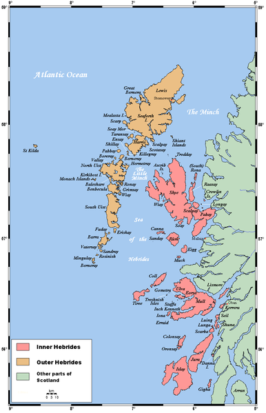
| 2006年1月28日 (六) 22:56 |  | 935 × 1,450(61 KB) | Mschlindwein | A map of the Inner and Outer Hebrides in Scotland. This map's source is [http://www.aquarius.geomar.de/omc/make_map.html here], with the uploader's modifications, and the [http://gmt.soest.hawaii.edu/ GMT homepage] says that the tools are released under |
文件用途
全域文件用途
以下其他wiki使用此文件:
- af.wikipedia.org上的用途
- an.wikipedia.org上的用途
- ar.wikipedia.org上的用途
- ast.wikipedia.org上的用途
- az.wikipedia.org上的用途
- bat-smg.wikipedia.org上的用途
- be.wikipedia.org上的用途
- bg.wikipedia.org上的用途
- bn.wikipedia.org上的用途
- br.wikipedia.org上的用途
- Ìle
- Inizi Gall
- Diùra
- Leòdhas
- Ulbha
- Beàrnaraigh Mòr
- Patrom:Inizi Gall
- Enez Cara
- Gioghaigh
- Rocabarraigh
- Inizi Barraigh
- Barraigh
- Bhatarsaigh
- Uibhist a Deas
- Hiort
- Uibhist a Tuath
- Ì Chaluim Chille
- Enez Sgitheanach
- Muile
- Na h-Eileanan Mora
- Na Hearadh
- Leòdhas agus na Hearadh
- Sgalpaigh na Hearadh
- Na h-Eileanan Ascrib
- Heisgeir
- Canaigh
- Càrna
- Rònaigh an Daimh
- Rònaigh (Sgitheanach)
- Cola
- Colbhasa
- The Minch
- Giogha
- Eige
- Orasaigh (Ìle)
- Orasaigh (Loch Bracadail)
- Rùm
查看此文件的更多全域用途。
