跳转到内容

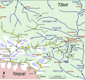
File:Map of Kharta region, east of Mount Everest.svg

页面内容不支持其他语言。
这个文件来自维基共享资源
维基百科,自由的百科全书

原始文件 (SVG文件,尺寸为1,279 × 1,194像素,文件大小:464 KB)


摘要

描述
English: Sketch map of w:Kharta and Kama velleys and environs, east of Mount Everest

The information on the map comes from File:Preliminary map of Mount Everest Expedition, 1921. Map I.jpg and
Reynolds, Kev (2011). "Trek 9, Kharta to the Kangshung Face". Everest : a trekker's guide : 9 treks in the Everest region, pp 234-235. Milnthorpe: Cicerone. ISBN 9781852846800. Retrieved 24 August 2014.
Howard-Bury, Charles; Mallory, George Leigh (1991). Keaney, Marian, ed. Everest Reconnaissance : The First Expedition of 1921, map "Approaches to Everest". London: Hodder & Stoughton. ISBN 0340556021.

plus information picked up in reading and web browsing. Villages and camps (red dots) are not distinguished and have not been included systematically. The Howard Bury book of the w:1921 British Mount Everest reconnaissance expedition mentions a number of villages in the lower Kharta Chu but does not name many of them. Glaciers are shown (schematically) roughly as they are at present. In 1921 they were larger – the Kangdushong Glacier went right across the Kama valley to the far side so blocking the progress of the Kangshung Glacier. Many place names have various romanisations and I have simply chosen one that seems appropriate. The red pecked line showing the routes taken in 1921 include routes taken by only some members of the expedition. However, routes taken by the surveyors have not been recorded. The green pecked line for present-day trekking is simply an example typical of what is being offered. Going to Samchung La (and on to Chog La) and back seems a shortish trek that some take.
日期
来源 自己的作品
作者 Thincat

许可协议

我,本作品著作权人,特此采用以下许可协议发表本作品:
w:zh:知识共享
署名 相同方式共享
本文件采用知识共享署名-相同方式共享 4.0 国际许可协议授权。
您可以自由地:
  • 共享 – 复制、发行并传播本作品
  • 修改 – 改编作品
惟须遵守下列条件:
  • 署名 – 您必须对作品进行署名,提供授权条款的链接,并说明是否对原始内容进行了更改。您可以用任何合理的方式来署名,但不得以任何方式表明许可人认可您或您的使用。
  • 相同方式共享 – 如果您再混合、转换或者基于本作品进行创作,您必须以与原先许可协议相同或相兼容的许可协议分发您贡献的作品。

说明

添加一行文字以描述该文件所表现的内容

此文件中描述的项目

描绘内容

文件来源 简体中文(已转写)

上传者的原创作品 简体中文(已转写)

数据大小 简体中文(已转写)

475,195 字节

1,194 像素

1,279 像素

image/svg+xml

校验和 简体中文(已转写)

b609e03f197f899ded02401523b3e57e5f4ba383

断定方法:​SHA-1 简体中文(已转写)

文件历史

点击某个日期/时间查看对应时刻的文件。

最新 | 最早) 查看(较新10条 | )(10 | 20 | 50 | 100 | 250 | 500
日期/时间缩⁠略⁠图大小用户备注
当前2014年8月26日 (二) 19:312014年8月26日 (二) 19:31版本的缩略图1,279 × 1,194(464 KB)Thincat1921 Everest reconnaissance routes and example trekking route shown
2014年8月25日 (一) 23:112014年8月25日 (一) 23:11版本的缩略图1,279 × 1,194(451 KB)ThincatMinor additions and corrections
2014年8月25日 (一) 16:192014年8月25日 (一) 16:19版本的缩略图1,279 × 1,194(422 KB)ThincatLumeh, Kangchungtse (Makalu II), ...
2014年8月25日 (一) 10:182014年8月25日 (一) 10:18版本的缩略图1,279 × 1,194(420 KB)ThincatExtended north
2014年8月24日 (日) 23:512014年8月24日 (日) 23:51版本的缩略图1,280 × 718(105 KB)ThincatLes violent colours
2014年8月24日 (日) 23:302014年8月24日 (日) 23:30版本的缩略图1,280 × 718(105 KB)ThincatAdd Rongbuk Glacier, etc.
2014年8月24日 (日) 22:452014年8月24日 (日) 22:45版本的缩略图1,280 × 718(102 KB)ThincatMore tidying
2014年8月24日 (日) 20:082014年8月24日 (日) 20:08版本的缩略图1,213 × 713(93 KB)ThincatSlight tidy
2014年8月24日 (日) 19:302014年8月24日 (日) 19:30版本的缩略图1,213 × 713(89 KB)ThincatCrop
2014年8月24日 (日) 19:252014年8月24日 (日) 19:25版本的缩略图1,231 × 844(87 KB)ThincatVarious. Continuing Kharta Chu, etc
最新 | 最早) 查看(较新10条 | )(10 | 20 | 50 | 100 | 250 | 500

以下3个页面使用本文件:

全域文件用途

以下其他wiki使用此文件:

元数据