跳转到内容

File:Concord Expedition and Patriot Messengers.jpg

页面内容不支持其他语言。
这个文件来自维基共享资源
维基百科,自由的百科全书

原始文件 (1,000 × 426像素,文件大小:139 KB,MIME类型:image/jpeg


本文件已被Concord Expedition and Patriot Messengers-en.svg取代。建议您使用其他文件。请注意,删除被取代的图片需要达成一致
new file
File:Concord Expedition and Patriot Messengers-en.svg是此文件的矢量版本。 如果此文件质量不低于原点阵图,就应该将这个JPG格式文件替换为此文件。

File:Concord Expedition and Patriot Messengers.jpg → File:Concord Expedition and Patriot Messengers-en.svg

更多信息请参阅Help:SVG/zh

其他语言
Alemannisch  Bahasa Indonesia  Bahasa Melayu  British English  català  čeština  dansk  Deutsch  eesti  English  español  Esperanto  euskara  français  Frysk  galego  hrvatski  Ido  italiano  lietuvių  magyar  Nederlands  norsk bokmål  norsk nynorsk  occitan  Plattdüütsch  polski  português  português do Brasil  română  Scots  sicilianu  slovenčina  slovenščina  suomi  svenska  Tiếng Việt  Türkçe  vèneto  Ελληνικά  беларуская (тарашкевіца)  български  македонски  нохчийн  русский  српски / srpski  татарча/tatarça  українська  ქართული  հայերեն  বাংলা  தமிழ்  മലയാളം  ไทย  한국어  日本語  简体中文  繁體中文  עברית  العربية  فارسی  +/−
新SVG图片

摘要

标题
英语:
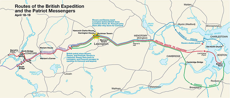
Routes of the British Expedition and the Patriot Messengers
title QS:P1476,en:"Routes of the British Expedition and the Patriot Messengers"
label QS:Len,"Routes of the British Expedition and the Patriot Messengers"
描写
Paul Revere's Midnight Ride
English: This is a map depiction the outbound routes taken by Patriot riders and British troops in the Battles of Lexington and Concord on April 19, 1775.
地图图例
 
British route to Concord
 
Revere's route
 
Dawes' route
 
Prescott's route
日期 未知日期; source PDF was created in 2000
来源 MIMAmap2.pdf 2005年5月10日 (上传日期) 通过 w:Flying Jazz (留言 | 贡献)
创作作者
未知Unknown author for National Park Service
 Geotemporal data
描绘日期
地图位置 波士顿, 马萨诸塞州
地图类型 thematic map
标题
地理参考 地理参考Wikimaps Warper中的地图 如果不适当,请设置 warp_status = skip 为隐藏。
 Bibliographic data
出版者
National Park Service
 Archival data
institution QS:P195,Q308439
题记

标题 上方 左侧:

Routes of the British Expedition and the Patriot Messengers
Text 中间:
Revere and Dawes reach Lexington before British leave Lechmere Point. Dr. Prescott joins them after they leave for Concord.
Text 中间:
British patrol stops Revere, Dawes, and Prescott. Revere is captured, Dawes flees back to Lexington, and Prescott escapes to continue to Concord and beyond.
其他版本


许可协议

Public domain This image or media file contains material based on a work of a National Park Service employee, created as part of that person's official duties. As a work of the U.S. federal government, such work is in the public domain in the United States. See the NPS website and NPS copyright policy for more information.


原始上传日志

Transferred from en.wikipedia to Commons by Andrei Stroe using CommonsHelper.

The original description page was here. All following user names refer to en.wikipedia.
  • 2005-05-10 09:58 Flying Jazz 1000×426× (141988 bytes) Routes of the British Expedition and the Patriot Messengers April 18-19 (1775) Minute Man National Historical Park Battle Map http://data2.itc.nps.gov/parks/mima/ppMaps/MIMAmap2.pdf {{PD-USGov-Interior-NPS}}
  • 2005-05-10 09:54 Flying Jazz 1000×426× (141988 bytes) Minute Man National Historical Park Battle Map http://data2.itc.nps.gov/parks/mima/ppMaps/MIMAmap2.pdf {{PD-USGov-Interior-NPS}}

说明

添加一行文字以描述该文件所表现的内容

此文件中描述的项目

描绘内容

image/jpeg

校验和 简体中文(已转写)

6d41ba675801bcccac169e02d6a8af6c7c2b117e

断定方法:​SHA-1 简体中文(已转写)

数据大小 简体中文(已转写)

141,988 字节

426 像素

1,000 像素

文件历史

点击某个日期/时间查看对应时刻的文件。

日期/时间缩⁠略⁠图大小用户备注
当前2010年11月22日 (一) 20:502010年11月22日 (一) 20:50版本的缩略图1,000 × 426(139 KB)File Upload Bot (Magnus Manske) {{BotMoveToCommons|en.wikipedia|year={{subst:CURRENTYEAR}}|month={{subst:CURRENTMONTHNAME}}|day={{subst:CURRENTDAY}}}} {{Information |Description={{en|This is a map depiction the outbound routes taken by Patriot ride

以下页面使用本文件:

全域文件用途

以下其他wiki使用此文件:

元数据