
File:Blue Ridge Parkway - schematic.jpg
原始文件 (6,615 × 4,440像素,文件大小:2.97 MB,MIME类型:image/jpeg)
摘要
| 描述 |
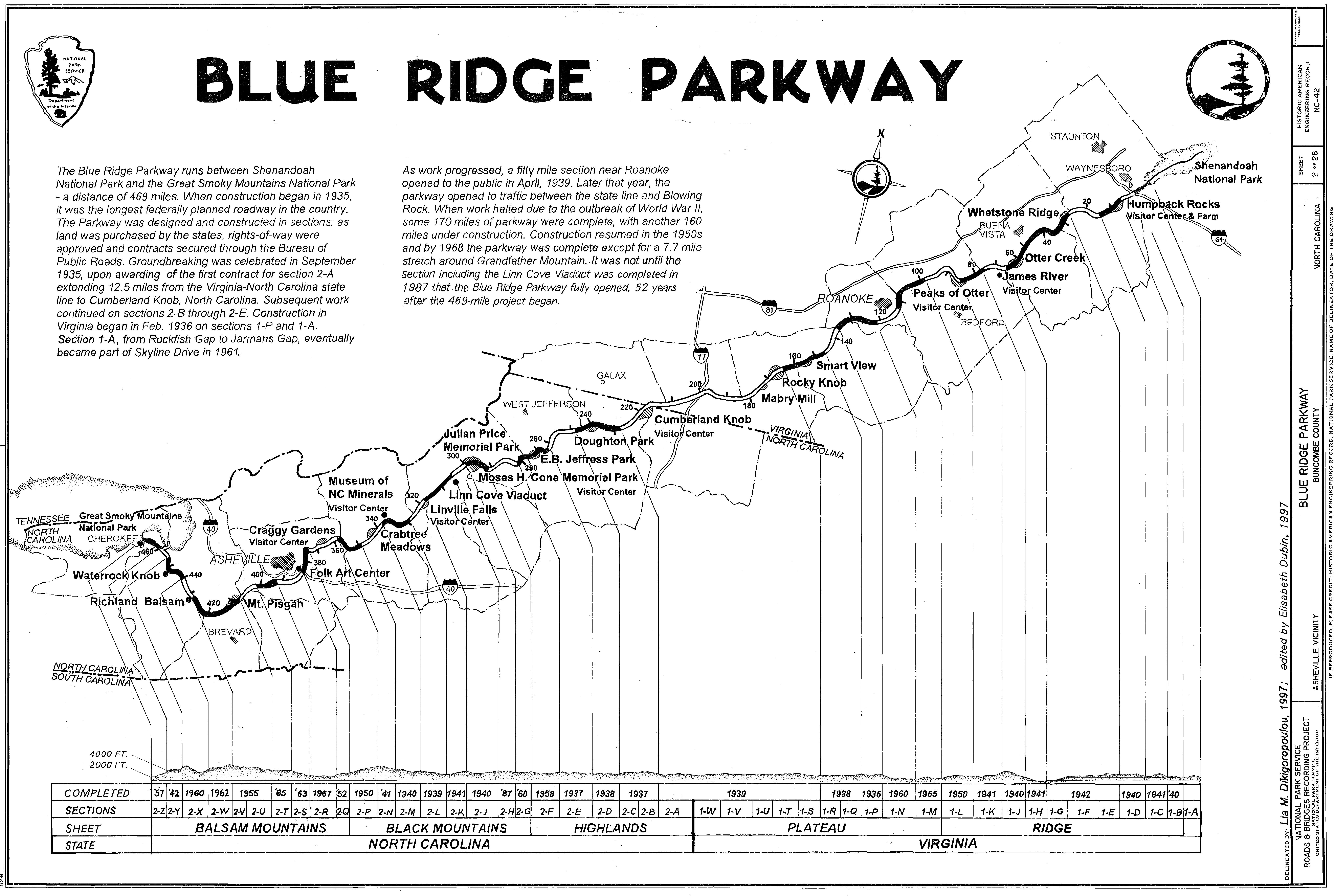
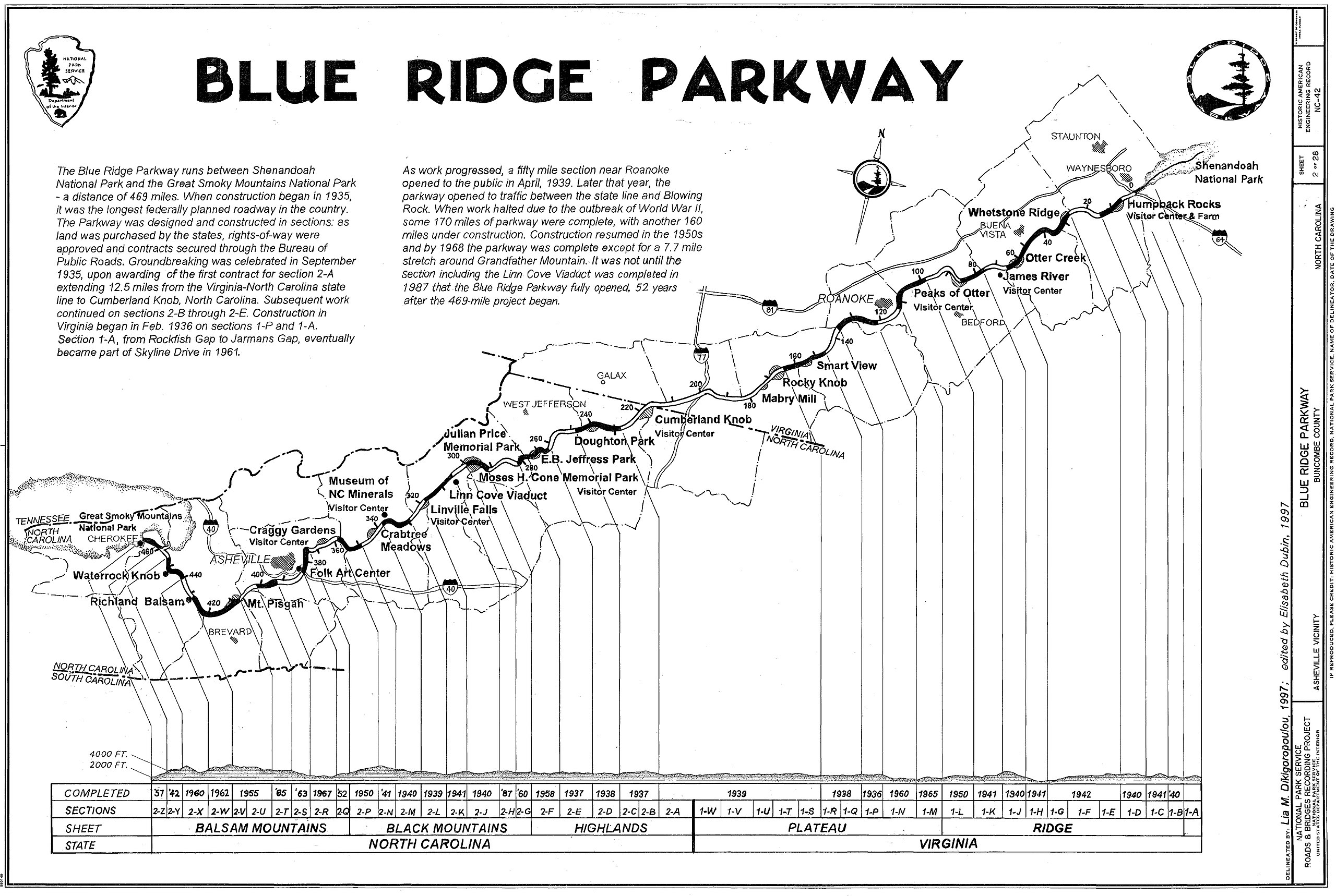
English: Blue Ridge Parkway, in Virginia and North Carolina, USA - A route schematic with elevations and points of interest.
Item Title Blue Ridge Parkway, Between Shenandoah National Park & Great Smoky Mountains, Asheville vicinity, Buncombe County, NC Alternate Title Blue Ridge Parkway Medium Measured Drawing(s): 28 (24 x 36) Photo(s): 243 (4 x 5 in.) Data Page(s): 344 plus cover page Color Transparencies: 17 Call Number HAER NC,11-ASHV.V,2- Created/Published Documentation compiled after 1968. Notes Survey number HAER NC-42 Unprocessed field note material exists for this structure (N517). Building/structure dates: 1935 initial construction Part of building/structure is in Cherokee, Swain County, NC. Subjects NORTH CAROLINA--Buncombe County--Asheville vicinity agriculture "Mission 66" program recreation Related Names Pratt, Dr. Joseph Hyde Byrd, Sen. Harry Flood Pollard, Gov. Johnathan MacDonald, Thomas Radcliffe, Sen. George L. Strauss, Theodore E. Quin, Richard, historian Weiner, Natascha, delineator Stormont, Matthew, delineator Rosa, Carlos Jimenez, delineator Haas, David, photographer Cuthbertson, Jennifer K., delineator Dubin, Elisabeth, delineator Reproduction Number [See Call Number] Collection Historic American Engineering Record (Library of Congress) Repository Library of Congress, Prints and Photograph Division, Washington, D.C. 20540 USA DIGID NC0478 |
||||
| 日期 | |||||
| 来源 |
|
||||
| 作者 | Lia M. Dikigoropoulou | ||||
| 授权 (二次使用本文件) |
|

原始上传日志
- 2006-05-15 20:44 Daderot 6615×4440×8 (3109567 bytes) Blue Ridge Parkway, Virginia and North Carolina, USA - route schematic with elevations and points of interest. This map was drawn in 1997. It is in the public domain because it was produced by the United States Government. This is a cropped image of drawi
文件历史
点击某个日期/时间查看对应时刻的文件。
| 日期/时间 | 缩略图 | 大小 | 用户 | 备注 | |
|---|---|---|---|---|---|
| 当前 | 2007年12月8日 (六) 20:07 | | 6,615 × 4,440(2.97 MB) | AEMoreira042281 | {{Information |Description={{en|Blue Ridge Parkway, Virginia and North Carolina, USA - route schematic with elevations and points of interest. This map was drawn in 1997. It is in the public domain because it was produced by the United States Government. |
文件用途
以下页面使用本文件:
全域文件用途
以下其他wiki使用此文件:
- en.wikipedia.org上的用途
- es.wikipedia.org上的用途
- fr.wikipedia.org上的用途
- www.wikidata.org上的用途