
File:Laizhou Bay, China ESA23271000.jpeg

本预览的尺寸:800 × 579像素。 其他分辨率:320 × 232像素 | 640 × 463像素 | 1,024 × 741像素 | 1,280 × 927像素 | 2,560 × 1,854像素 | 19,600 × 14,192像素。
原始文件 (19,600 × 14,192像素,文件大小:10.91 MB,MIME类型:image/jpeg)
摘要
| 警告 | 部分浏览器在浏览此图片的完整大小时可能会遇到困难:该图片中有数量巨大的像素点,可能无法完全载入或者导致您的浏览器停止响应。 |
|---|
| 描述 |
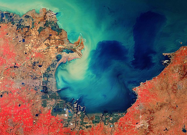
English: The Copernicus Sentinel-2 mission takes us over the sediment-stained waters in Laizhou Bay, located on the southern shores of the Bohai Sea, on the east coast of mainland China. Zoom in to see this image at its full 10 m resolution or click on the circles to learn more about the features in it. The bay is the smallest of three main bays of the Bohai Sea, and is named after the city of Laizhou, visible to the east. Large quantities of sediment carried by the Yellow River, visible in the left of the image, discolour the waters of the bay and appear turquoise. This sediment can be seen throughout the waters in this image, even far from the coast. The Yellow River is China’s second longest river, with a length of over 5400 km, and is surpassed only by the Yangtze River. The river rises in the Bayan Har Mountains in Western China and flows through nine provinces before emptying into the Laizhou Bay. Its drainage basin is the third largest in the country, with an area of around 750 000 sq km. The river is estimated to carry 1.6 billion tonnes of silt annually, carrying the majority to the sea. Owing to this heavy load of silt, the Yellow River deposits soil in stretches, ultimately elevating the river bed. Excessive sediment deposits have raised the river bed several metres above the surrounding ground, sometimes causing damaging floods. On the southern coast of Laizhou Bay, in the bottom of the image, flooded fields are visible and are most likely artificial fish farms. The city of Dongying, home to the second largest oilfield in China, is visible in the left of the image. This image was processed in a way that included the near-infrared channel, which makes vegetation appear bright red. The lush vegetation can be distinguished from the brown fields in the image, which are unharvested or not yet fully grown. Copernicus Sentinel-2 is a two-satellite mission. Each satellite carries a high-resolution camera that images Earth’s surface in 13 spectral bands. The mission is mostly used to track changes in the way land is being used and to monitor the health of vegetation. This image, acquired on 26 February 2020, is also featured on the Earth from Space video programme. |
| 日期 | 2021年4月23日 (上传日期) |
| 来源 | Laizhou Bay, China |
| 作者 | European Space Agency |
| 其他版本 |
|
| Activity | Observing the Earth |
| Mission | Sentinel-2 |
| Set | Earth observation image of the week |
| System | Copernicus |

许可协议

|
此图像包含来自哥白尼计划中的卫星的数据,例如哨兵1号、哨兵2号或哨兵3号。使用此图片时需要注明出处。
署名: 包含修改后的哥白尼哨兵数据2020
哥白尼哨兵数据的使用受欧盟法律监管(委员会授权条例 (EU) No 1159/2013和条例 (EU) No 377/2014)。相关摘录:
应免费访问通过GMES传播平台提供的GMES专用数据[...]。
在合法的范围内应出于以下用途的目的访问GMES专用数据[...]:
GMES专用数据[...]可在全球范围内不受时间限制地使用。
向用户提供GMES专用数据和GMES服务信息没有任何明示或暗示的保证,包括关于质量和任何目的的适用性。 |
This media was created by the European Space Agency (ESA).
Where expressly so stated, images or videos are covered by the Creative Commons Attribution-ShareAlike 3.0 IGO (CC BY-SA 3.0 IGO) licence, ESA being an Intergovernmental Organisation (IGO), as defined by the CC BY-SA 3.0 IGO licence. The user is allowed under the terms and conditions of the CC BY-SA 3.0 IGO license to Reproduce, Distribute and Publicly Perform the ESA images and videos released under CC BY-SA 3.0 IGO licence and the Adaptations thereof, without further explicit permission being necessary, for as long as the user complies with the conditions and restrictions set forth in the CC BY-SA 3.0 IGO licence, these including that:
See the ESA Creative Commons copyright notice for complete information, and this article for additional details.
|
 | |
本文件采用知识共享署名-相同方式共享 3.0 政府间组织许可协议授权。 署名: ESA, CC BY-SA IGO 3.0
| ||
文件历史
点击某个日期/时间查看对应时刻的文件。
| 日期/时间 | 缩略图 | 大小 | 用户 | 备注 | |
|---|---|---|---|---|---|
| 当前 | 2021年4月23日 (五) 10:27 | | 19,600 × 14,192(10.91 MB) | OptimusPrimeBot | #Spacemedia - Upload of https://www.esa.int/var/esa/storage/images/esa_multimedia/images/2021/04/laizhou_bay_china/23270990-1-eng-GB/Laizhou_Bay_China.jpg via Commons:Spacemedia |
文件用途
以下页面使用本文件: