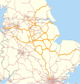
File:East Midlands route map 2010.svg
外观

此SVG文件的PNG预览的大小:574 × 599像素。 其他分辨率:230 × 240像素 | 460 × 480像素 | 736 × 768像素 | 981 × 1,024像素 | 1,962 × 2,048像素 | 1,002 × 1,046像素。
原始文件 (SVG文件,尺寸为1,002 × 1,046像素,文件大小:1.42 MB)
文件历史
点击某个日期/时间查看对应时刻的文件。
| 日期/时间 | 缩略图 | 大小 | 用户 | 备注 | |
|---|---|---|---|---|---|
| 当前 | 2011年8月25日 (四) 22:40 |  | 1,002 × 1,046(1.42 MB) | Nilfanion | fixing other routes |
| 2011年2月5日 (六) 19:14 |  | 1,002 × 1,046(1.35 MB) | Nilfanion | == Summary == {{Information |Description=Map showing railway routes operated by East Midlands Trains in 2010. The background map shows the coastline and major urban areas. Equirectangular map projection on WGS 84 datum, with N/S |
文件用途
以下页面使用本文件:
全域文件用途
以下其他wiki使用此文件:
- en.wikipedia.org上的用途
- simple.wikipedia.org上的用途
- www.wikidata.org上的用途


