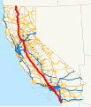
File:California Interstate 5.svg
外观

此SVG文件的PNG预览的大小:514 × 600像素。 其他分辨率:206 × 240像素 | 411 × 480像素 | 658 × 768像素 | 878 × 1,024像素 | 1,755 × 2,048像素 | 576 × 672像素。
原始文件 (SVG文件,尺寸为576 × 672像素,文件大小:1.62 MB)
文件历史
点击某个日期/时间查看对应时刻的文件。
| 日期/时间 | 缩略图 | 大小 | 用户 | 备注 | |
|---|---|---|---|---|---|
| 当前 | 2007年12月18日 (二) 12:58 |  | 576 × 672(1.62 MB) | NE2 | Oops - SR 99 wasn't blue north of Manteca. |
| 2007年12月18日 (二) 10:51 |  | 576 × 672(1.62 MB) | NE2 | Thinned the lines. | |
| 2007年12月18日 (二) 10:47 |  | 576 × 672(1.62 MB) | NE2 | == Summary == This is a map of Interstate 5 in California. Email me if you would like a copy of the GIS data I created for the highways. Category:Interstate 5 in California [[Category:Maps of state highways in California|005 |
文件用途
以下页面使用本文件:
全域文件用途
以下其他wiki使用此文件:
- ar.wikipedia.org上的用途
- en.wikipedia.org上的用途
- es.wikipedia.org上的用途
- ru.wikipedia.org上的用途
- uk.wikipedia.org上的用途
- www.wikidata.org上的用途

